A Loop That Comes Back to Its Landmarks
A loop route built around visible landmarks is easier to follow and adjust without distance targets, with practical options for choosing a route that suits you.
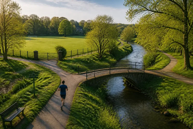
The common mistake with a loop route is treating it as a line on a map: follow the path, turn somewhere, and hope the way back is obvious. The cost is a run spent checking directions at every junction, or an awkward detour when a path is closed. A loop route built around landmarks gives you a simpler job: recognise a place, make one clear decision, and keep moving.
A landmark-led loop is not a substitute for a map or local knowledge. It is a way to make the route legible as you run, without asking distance targets to do all the organising. A bridge, playing-field entrance, broad stand of trees or distinctive bend can tell you where you are and what comes next. The useful question is not how far you have gone, but whether the next part still makes sense.
What makes a landmark useful on a loop route?
A useful landmark is visible from the route, easy to distinguish from its surroundings and associated with a decision. “The large oak near the fork” is more helpful than “some trees”; “the footbridge over the stream” gives you a location and a reason to turn. You should be able to recognise it at running pace, in ordinary light, without stopping to inspect every sign.
Landmarks can be natural or built. A river crossing, ridge, open field, church tower, allotment gate, railway bridge or junction beside a familiar building may all work. The best choice depends on the place. In a park, a bandstand or the entrance to a sports ground may be clearer than a distant skyline. On a riverside path, a bridge may do more useful work than a row of similar benches.
Think in terms of a small sequence rather than a collection. Each landmark should either confirm that you are on the intended route or prompt a clear choice: carry on, turn, cross, or begin the return. Too many markers become a scavenger hunt with running shoes. Too few leave you guessing between them.
Should you use a loop with a central landmark or several turns?
There are three sensible approaches. They suit different places and different appetites for route decisions; none needs a distance target to make the route coherent.
Is an out-and-back loop around one landmark easiest to follow?
This approach uses a prominent feature as the far point: a bridge, viewpoint, lake edge or public green. You run towards it, make a circuit or use a different path nearby, then return by a recognisable corridor. It suits someone new to the area, or anyone who wants one main decision rather than a string of junctions.
Its weakness is that the landmark may be visible without being accessible by the path you expected. A river, fence or steep bank can make a tempting shortcut impractical. Check that there is a public route around or past the feature, and choose a backup turning point if access changes.
Does a chain of landmarks make a better loop?
A chain uses several distinct places to guide you around the route: perhaps a library corner, a bridge, a playing field and a tree-lined avenue. It suits runners who enjoy exploring and can remember a short sequence of cues. The loop feels less repetitive because the landmarks divide it into recognisable sections.
The trade-off is more opportunities to misread a junction. Give every turning point a specific cue, not a vague direction such as “left after the park”. If two paths meet near the same landmark, note what you should see immediately after the turn. That confirmation helps catch a mistake early.
When is a figure-eight route the better choice?
A figure-eight uses a central crossing or shared landmark to join two smaller loops. It suits a runner who wants a choice about how much of the route to complete: one circuit can be enough, while the second remains available if conditions and energy allow. It also gives a clear place to shorten the outing without inventing a route on the move.
The central point needs to be easy to recognise from both approaches, and the crossing should be appropriate for pedestrians. Avoid making a busy road crossing the route’s organising feature. If the two loops depend on confusing paths or a narrow passage, the apparent flexibility may be more trouble than it is worth.
How do you choose between these approaches?
Start with the landscape you actually have. A compact park with a lake may lend itself to one central landmark. A district with a river path, sports grounds and several public lanes may suit a chain. If the area has one obvious meeting point and usable paths in different directions, a figure-eight can offer options without requiring an entirely new route.
Then consider what you want to decide while running. If you prefer to make few decisions, choose a route with one far point and a clear return. If you like variety, use a chain with distinct cues. If you want to choose between a shorter and longer outing at a known place, consider two linked loops. This is a choice about route shape, not a test of ambition.
Walk the tricky junctions before relying on them, especially where paths divide or meet roads. A local map can show public paths and possible connections; street signs and park notices help establish whether an access point is open. For access, closures or route restrictions, follow posted signs and local rules. The route should work in the conditions you can reasonably expect, not only on a clear day when every distant feature is visible.
Say you run in a park crossed by a stream, with a footbridge near the entrance and a sports field beyond it. You could use the bridge as the shared point of a figure-eight: the first circuit follows the field edge and returns to the bridge, while the second follows the stream path before coming back. If the stream path is blocked, the field circuit still forms a recognisable outing; the observable result is a route with a clear stopping choice rather than a forced detour.
How can landmarks help you adjust the route?
Landmarks make adjustment easier when you decide in advance which choices are available. At a named junction, you might have a short return path, a longer circuit or a direct route home. The options need not be measured. They need to be distinct enough that you can choose without studying a map while moving.
Use places as decision points, not as promises about how you should feel. At the bridge, you can continue around the second loop or take the path back. At the sports-ground entrance, you can leave the park if the weather turns or the paths become uncomfortable underfoot. A landmark does not tell you whether to continue; it makes the available routes easier to see.
Keep one alternative for a blocked path or a change in conditions. It might be a parallel public path, a return by the way you came, or an exit to a familiar street. If the route depends on a seasonal gate, a narrow muddy cut-through or a path hidden by vegetation, treat that connection as uncertain and plan a simpler return.
What should you check before following a landmark loop?
- Distinctiveness: Can you tell the landmark from similar features at running pace? If not, choose a more recognisable cue.
- Visibility: Will it remain easy to see in the likely light and weather? If not, add a closer cue at the junction.
- Path connection: Is there a usable route to the next landmark? If the connection is unclear, inspect it on a map or choose another route.
- Turning decision: Does the landmark tell you exactly where to go next? If not, add a brief description of the turn.
- Return option: Can you shorten the loop or retrace your route from a recognisable point? If not, identify a simpler way back.
- Access: Are the paths and crossings open to pedestrians? If signs or barriers say otherwise, use another connection.
- Overlap: Does the route reuse a path in a way that will leave you uncertain about direction? If so, add a distinctive cue for the outward and return legs.
These checks are about clarity, not making a route immune to change. A park can close an entrance; a familiar path can be obscured by work or weather. The point is to have a simple response when the route differs from the picture in your head.
How do you remember the route without a distance target?
Describe it as a short set of actions tied to places: “follow the canal to the stone bridge, cross, turn beside the playing field, return through the main gate.” This is easier to recall than a string of turns without context. If the sequence is long, save a map on your phone or note the junctions before setting out. You can use that reference without turning the run into a navigation exercise.
Give directional words a fixed viewpoint. “Left at the footbridge” is ambiguous if you approach from the other side, so note whether you cross before turning or take the path that runs beside the water. Likewise, “go around the field” should say which edge or which entrance, when more than one is available.
One small marker can be more useful than a grand landmark. A painted path post, a particular gate or a junction where a paved path becomes gravel may confirm that you are on the right track. Do not rely on a feature that can disappear in darkness or resemble several others. A route that requires forensic attention to shrubbery has lost the plot.
What questions do runners ask about landmark loops?
Can I plan a loop without knowing its distance?
Yes. Choose a route by its landmarks, crossings and available return options, then decide how long to continue based on how the outing is going. If distance matters for a particular reason, check a map separately rather than guessing from the landmarks.
What if a landmark is hard to see?
Use a nearer cue at the decision point, such as a signed junction, bridge entrance or change in path surface. Keep a map available if poor light, weather or unfamiliar surroundings could make the route difficult to recognise.
Is it better to reuse part of the route on the way back?
That often makes a loop easier to follow, especially in unfamiliar surroundings, because one section is already known. If you want more variety, use a different return path only when it is clear, accessible and easy to reconnect to a familiar landmark.
What is the simplest way to shorten a landmark loop?
Choose a point on the route where a familiar path leads back towards your start, and remember it as an exit before you set out. A shortcut is useful only if you can recognise it and follow it without creating a new navigation problem.
Which route shape should you take?
Choose the single-landmark route when simplicity matters most, a chain when the area offers a series of unmistakable cues, and a figure-eight when two distinct circuits can share a clear centre. The best landmark loop is the one whose turns you can explain plainly and whose return remains understandable if you decide to change it.
Before setting off, name the first landmark and the place where you can turn back or shorten the outing. That small piece of preparation makes a landmark-led loop easier to adjust without distance targets, while leaving you free to pay attention to the route itself rather than repeatedly asking where it went.